Feature Article
Getting to Know a Place: Site Evaluation as a Starting Point for Green Design
The National Wildflower Research Center outside of Austin, Texas blends beautifully with the land on which it sits—a cluster of buildings connected by rich landscapes of native plants; rainwater harvesting to minimize depletion of the threatened Edwards Aquifer; walking paths through meadow, prairie, and woodland ecosystems; and carefully designed parking areas to filter and purify stormwater before it seeps into the ground. A thousand miles northeast and like many subdivisions outside Chicago, Prairie Crossing is being built on productive farmland. But unlike most, the homes here are clustered on just a small portion of the land, the rest being used in active agriculture or restored to the native tall-grass prairie that once existed here. And on the rugged Big Sur coast, Post Ranch Inn—the first commercial development in decades in what is one of the nation’s most anti-development areas—blends seemlessly into the environment, its modules of lodging rooms half-buried and barely visible to either hiker or the extreme winds that pound the hillside.
What these places share is a connection to the site. Their designs were integrated into the local ecosystem after careful study of what was there and how the natural beauty and health of that ecosystem could be protected, restored, and celebrated. This link between development and the land is all-too-often neglected. Indeed, landscape design is often an afterthought, a plan addressing which shrubs to plant that is developed after the building is completed (budget permitting), with total disregard for what the original building site offered to start with and what its ecosystem calls out for.
This article addresses what should be the first step in most green building projects (certainly those on “greenfield” sites): getting to know a place. This component of the development process should include, whenever possible, a landscape architect or designer. With or without such specialists, however, it is important for all players on a development team to recognize the importance of site evaluation and to understand the site planning and design priorities that emerge from this site evaluation. As landscape architect Walt Cudnohufsky, founder of The Conway School of Landscape Design, points out, we need to “give the environment a voice.” The following pages will introduce this topic, outline key components, and provide simple checklists that can serve as a starting point for ecologically integrated building and landscape design.
Landforms
Careful site evaluation will help identify the best building site.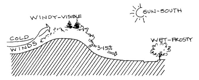
Much of this information is now digitally available in a standardized GIS (Geographic Information System) format that can be used in many CAD software programs.
Geology
The underlying geology of a site influences topography, depth to bedrock, soil composition and fertility, drainage, subsurface water, and vegetation types. While soils are more direct in their influence on vegetation and land uses, a great deal can be learned from an area’s geology, and it makes a good starting point in site investigations. Examine geological maps produced on state or regional scales by the U.S. Geological Survey (USGS). Consider visiting a nearby college or university offering a geology program; use the library or speak to a professor to learn more about the geology of your region.
Topography
Steep slopes are susceptible to erosion and are best protected from development. Just how steep a slope can be before erosion becomes a significant concern depends on the soils; slopes in excess of 30% are rarely developable, and even 15% will be too steep for some soils. On the other hand, flat parcels of land do not offer as good drainage and they are often better used for agriculture, parking, and recreation. Pockets of low-lying land may be ecologically important (and fragile) wetlands.
Slope is usually described as “percent grade.” This is the ratio of rise over run, given as a percentage; in other words, a 45° slope would have a 100% grade. USGS topographic maps usually do not have high enough resolution to show site-specific topography clearly. Contour maps derived from digital, aerial
orthophotos can offer more detail, but are not available for all locations. It is often advisable to have a more detailed and accurate field survey performed of the property, or at least those portions of the property to be developed.
Soils
Soils are created by the breakdown of bedrock and sediments, by the deposition of organic matter from above, and by the action of living organisms and natural forces (water and wind) in mixing and modifying those components. Properties of soil determine how readily moisture can seep into the ground, whether expansion with moisture will cause foundations to buckle or crack, how significant a concern soil compaction is (risk of construction damage to trees), and what sort of plantings will prosper with what level of care.
Excellent information on soils is usually available from the federally funded Natural Resources Conservation Service (previously the Soil Conservation Service). NRCS publishes highly detailed, county soil maps that are available from state or county NRCS offices or from county agricultural extension offices. On these maps—superimposed on aerial photographs—soils are delineated and classified according to a widely accepted system that relates the physical properties of the soil to its development potential and constraints. Such information as depth to bedrock and depth to the water table can be learned from the maps and explanatory text. An experienced landscape architect, civil engineer, or soils technician can use this information to provide valuable guidance to the site planning process, determining appropriate locations for buildings, septic system drainage fields, stormwater infiltration beds, driveways, etc.
Hydrology
Surface waters, wetlands, and groundwater are critically important. Surface waters and wetlands, including ponds, streams, seasonal (vernal) ponds, and estuaries, tend to be our richest and most diverse ecosystems, and they can easily be damaged by development. Groundwater is a resource that may have only minimal direct impact on a particular site being developed, but its purity is an important issue downslope where it seeps to the surface or is pumped out of the ground as potable water.
All surface waters and wetlands on a site being considered for development should be mapped. Hydrologic maps may be available from USGS, NRCS, or a local planning agency. National Wetlands Inventory mapping is also available, showing significant wetland areas. All of this hydrologic mapping information, however, is quite general; more detailed information should always be collected through on-site investigations. The most difficult of these are detailed wetland inventories, because wetlands may not be as obvious as other surface waters. There are various definitions of wetlands that are used by different agencies. In general, wetlands have one or more of the following characteristics: the presence of water on the surface (usually relatively shallow) for all or part of the year; the presence of distinctive, recognizable soils, usually with high organic content or anearobic conditions; and the presence of vegetation that is adapted to—and indicative of—wet soils, surface water, and/or flooding. Very often, wetlands are subdivided into several classifications. A hydrologic map should show all surface waters as well as wetlands, divided into subtypes when possible. Wetlands delineation is generally required by regulatory bodies.
General information on groundwater can be obtained from geologic, hydrologic, or soils maps, but as with the surface waters and wetlands maps, these will rarely be very precise. Data on drilled wells in the area might also be available from the state or county. Knowing the depth and recharge rate of drilled wells in your area will help you get a sense of what you can expect on your site. If extremely deep wells with very low recharge rates are the norm, for example, that might suggest that such strategies as xeriscaping and rainwater catchment should be considered.
Vegetation
Protect trees and wetlands during construction.
This information can be used to plan a strategy for protecting or restoring native ecosystems that will support healthy and productive biodiversity on the site. It can also be used to figure out where buildings and roadways would be most appropriate. Building placement may make the most sense on ecologically damaged areas of a site, for example, or where natural shading will help reduce cooling loads. Vegetation can also have a significant impact on views, wind blockage, the microclimate, sound control (here the effect is less than a lot of people assume), and even property values—a single large shade tree left on a building lot can enhance the value of a new home by thousands of dollars (see
EBN
Vol. 4, No. 1, p. 4).
Any detailed evaluation of a site should include a careful inventory of vegetation. Vegetation can be classified in a number or ways, including floristic (classification by species), and physiognomic (classification by form and function—forest, woodland, grassland, etc.). Often, the vegetation analysis will categorize the vegetation types into different levels, each based on a different classification type. A very detailed vegetation inventory might also include mapping of individual trees. At the 1600- acre (647 ha) Haymount development south of Washington, D.C., which should ultimately include more than 4,000 housing units along with commercial development, all trees over 18 inches (450 mm) in diameter were mapped in an effort to figure out where development would have the least impact. Existing trees over 6 inches (150 mm) in diameter may only be removed with permission of the Town Architect’s office, according to the plan. Very generalized vegetation maps might be available locally or regionally, based on satellite analysis or aerial photographs. Also, critical habitat maps showing approximate locations of endangered or threatened plant species may be available from a state or regional agency.
On many sites, particularly those where extensive disturbance has occurred, the vegetation will be dominated by introduced (or invasive) plant species. Most ecological landscaping professionals argue that native vegetation is preferable to nonnative vegetation, because it is part of an established ecosystem. But agricultural uses of land are also important, and preserving agricultural lands may be a high priority for many green development projects.
Wildlife Habitat
Whenever possible, limit development on rural “greenfield” sites to a small portion of the site.
contiguous wildlife corridors. Roadways and even a line of low-density development can provide imposing barriers to wildlife movement, whether white-tailed deer, box turtles, or songbirds.
Your state wildlife or fish-and-game agency may have information on wildlife habitat, but the emphasis of that research is often on game species, such as deer, wild turkey, and bear, rather than less prominent wildlife. Many states also maintain offices that address nongame wildlife, including threatened species. If that sort of information is not available from a government agency, contact your state office of The Nature Conservancy, which may compile information on threatened habitat. It is worth noting here that even urban areas can offer significant wildlife habitat. Some of the most important migratory waterfowl stopover locations are within city limits of places like Philadelphia, and ecologically rich stream corridors run through many cities.
Climate and Microclimate
Information on the local climate—temperature, insolation (solar radiation), wind, and precipitation—is critically important for the energy design of buildings. It can also be used in planning appropriate landscape plantings on a site.
Temperature
There are various types of temperature data we can use.
Design temperatures (the reasonably expected minimum winter temperature and maximum temperature) are needed to size mechanical equipment.
Heating degree-day and
cooling degree-day information tells us the overall magnitude of the heating and cooling seasons, or portions thereof. Degree-days are computed by averaging high and low temperatures each day and calculating the difference from a base temperature—in the I-P system, the standard base temperature is 65°F for heating and 75°F for cooling.
Design temperatures, as well as both monthly and annual degree-day averages, are widely available for hundreds of locations around the country. For U.S. locations, the most accessible data is from the National Climate Data Center of the National Oceanographic and Atmospheric Administration, NOAA (http://www.ncdc.noaa.gov/). Local heating degree-day information is usually available from fuel oil or propane gas companies, which use it for scheduling fuel deliveries. While these sources of temperature information are very useful, keep in mind that there can be significant variations based on elevation, topography, and microclimate. Temperatures drop with elevation (adiabatic cooling) by about 3-5°F for every 1000 feet (1.7-2.8°C per 1000 m) of elevation rise, for example, but this can be offset by the tendency of cool, dense air to flow down hillsides and collect in low-lying pockets. Orientation of a slope (aspect) also affects temperature: south-facing slopes are considerably warmer than north-facing slopes because they receive more solar radiation.
Related to temperature is information on the growing season. This can include the average dates of first and last killing frosts and the U.S. Department of Agriculture (USDA) “Plant Hardiness Zone Map,” which is widely published in garden books.
Insolation and solar access
Trees and other vegetation can help modify the microclimate around buildings.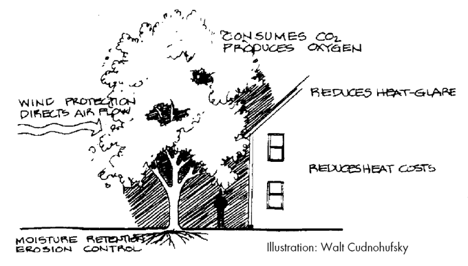
Look for measured or averaged data for horizontal surfaces in Btus/square foot or Watt-hours/square meter. Information on percent sunshine or cloud cover may also be available from some sources.
Evaluating solar access is a very different process than finding out how much sunshine is available regionally. Solar access varies widely on a particular site, depending on orientation, slope, nearby topography (hills, mountains), and vegetation on the site. Relative to building design, solar access generally refers to access to the sun’s apparent path across the southern sky (in the northern hemisphere). Various devices were developed during the 1970s to simplify the task of determining solar access on a particular site, a few of which are still on the market. Solar access can often be modified significantly by shifting the planned location of a building or removing trees to the south of a building site.
Wind
Wind can be both beneficial and detrimental to the energy performance of a building, and it can determine to a great extent appropriate locations for landscape plantings. From a building standpoint, plantings can shield a building from cold winter winds, or help channel cool summer breezes into a building, helping reduce air conditioning requirements. Throughout much of North America, prevailing winds are from the west. However, even though prevailing winds may be predominantly from one direction, there are usually significant periods of time when the winds are blowing from a different direction. Plus, there is significant local variation as a result of mountains, hills, river valleys, even buildings and roadways.
Wind data is available from weather stations, airports, and some universities and research laboratories. The nearest wind data collection point will provide valuable information, as long as local (microclimate) variation is considered. One of the most useful pieces of information on wind is a wind rose. This shows graphically the amount of time prevailing winds are from the 16 subdivisions of a compass (N, NNE, NE, ENE, etc.). To be most useful, try to obtain wind rose data for different seasons, so you can see whether the prevailing winds change seasonally. For a particular site, anecdotal information from neighbors can be particularly useful. Or, wind data can be collected on-site over a period of time—because of seasonal differences, monitoring wind for a full year is ideal.
Precipitation
Shared driveways make sense—whether the development is residential or commercial.
intensity-duration-frequency (IDF) curves, is available from the U.S. Weather Bureau (Technical Paper No. 40) and the National Oceanographic and Atmospheric Administration (Hydro-35). State highway departments and NRCS offices may be other sources of precipitation data.
Knowing the expected quantity and nature of precipitation will help you decide on appropriate plantings around the planned building(s) and also help you establish priorities regarding water conservation, graywater use for landscaping, and rainwater harvesting. In arid regions, for example, xeriscaping will be a higher priority than in wetter areas. Rainwater catchment makes sense in areas with moderate rainfall—little enough that water is a highly valued resource, but enough (and spread out enough) that it can be depended on for the planned uses. According to some experts, rainwater harvesting makes the most sense when precipitation is between 15 and 30 inches (40-80 mm) per year. If storm events are severe but spread far apart, the landscape plan needs to address stormwater management and infiltration very carefully to avoid significant downstream impacts. Finally, in colder climates, expected winter snowfall needs to be considered relative to building design and plantings.
Humidity
The final climatic condition we will address here is relative humidity—how much moisture is in the air relative to the maximum amount that the air could hold. In buildings, humidity is an important determinant of comfort and a condition that needs to be considered in selecting cooling strategies and equipment. In low-humidity areas, for example, evaporative coolers provide a cost-effective air conditioning strategy, but they don’t work well in humid climates. Similarly, the strategy of opening a building up at night and closing it during the day in the summer for natural cooling is less effective in very humid areas where moisture-laden nighttime air can result in mildew problems or require use of dehumidification equipment.
History of the Land Use
While this article focuses primarily on physical, climatological, and ecological aspects of a property, the historical influences can also be an important factor in site planning and design decisions. Past human influences need not be ignored; in some cases they should even be celebrated. What existed on the site previously? Is there evidence of previous settlement? What stories do the old stone walls winding through a New England woodland tell? What is the history of an adobe home ruins on a Southwest mesa? There may have been wisdom in the way an early carriage path crossed a piece of land, as evidenced by an ancient row of trees and subtle depression in a hillside. The placement and orientation of early settlers’ homes, as evidenced by the remaining ruins, can tell us volumes.
Information on the history of a piece of land can be elusive but fascinating. It can take you to early land deeds, discussions with old-timers still in the area, published histories of the region, historical society libraries, and on-site investigations. A number of prominent green development projects have made extensive use of archaeological investigations to learn about the history of the land use, even prior to European settlement.
Aesthetics and Views
Even clustered buildings can afford privacy and provide views.
Designing a building to make it easier for the occupants to appreciate their surroundings may increase their motivation to protect or restore the land around them. How will the building placement on a property impact the views and aesthetics of the land? When Brattleboro, Vermont landscape architect Monroe Whitaker, of Stevens Consulting Engineers, walks a piece of land with property owners planning to build, he always asks what it is they particularly like about the property. Very often he finds that it is the views of the land. When they get to the point of siting a home on the land, he asks them to think about how that building will affect their appreciation of the land. It is not uncommon for him to find that the envisioned home will destroy just what the property owners most love about the land—because the house would sit right in the middle of the open meadow that dominates the viewscape. Through this envisioning process, Whitaker helps them find a building site that will preserve the aesthetic qualities of the land that initially attracted them to it. Walking the land—in all times of day and year—is the best way to learn what it holds from an aesthetic standpoint.
Toxics Inventory
On any piece of land where there has been significant use over the past hundred years, it is a good idea to investigate whether toxic materials might be present. Old farm dumps can contain corroding barrels of highly toxic pesticides. Old autos can leak oil, gasoline, antifreeze, and other fluids into soils, surface waters or groundwater. An abandoned electrical transformer could be leaking PCBs. Discarded automobile batteries can release lead into the environment. In extreme cases, the discovery of hazardous waste on a property can result in thousands of dollars of expense in clean-up.
Inventories of known hazardous sites exist and are available from state agencies that deal with pollution control. Unfortunately, most of the farm dumps and other minor sources of toxics are not documented in published inventories. In most cases, a careful walking of the land will determine whether there is enough concern about toxics to warrant a more thorough investigation. If there are no apparent signs of a dump, past industrial activities, or other red flags, then it is probably not necessary to go any further. If areas of potential concern do show up, they should be investigated by a qualified environmental engineer. If remediation is necessary, the environmental engineer should be able to advise you on how to proceed, and put you in touch with relevant agencies to help you come up with a workable plan. (More complete discussion of development on brownfield sites will be provided in a future issue of
EBN.)
Integration with Surrounding Region
A building site is not an entity unto itself, but rather part of a broader built and unbuilt environment. An important part of site assessment is examining how this particular property—and the buildings on it—will relate to surrounding sites and the region. Cudnohufsky stresses that part of the analysis of a site needs to be its connection with the area. “Don’t forget to look outward from the site,” he told
EBN. “There is a different relationship on each boundary of the property.” Consider the connection with nonfragmented wildlife habitat on abutting lands, protection of regional surface waters and wetlands, and integration with regional transportation systems that provide alternatives to automobile travel. Are there bicycle trails and pathways that can be linked to? Are there public transit options that people living or working at the site can use?
To examine local and regional planning issues, contact a town, county, or regional planning agency and get hold of relevant planning documents, such as a town plan or regional plan. Talk to the planning director for the municipality, if there is one, or attend meetings of the planning commission with jurisdiction to get a sense of their priorities relative to planning. Not only can this help you figure out how to make sure your project will fit into the surrounding area better, but it can streamline approvals that may be required for your particular project.
Regulatory Constraints
The best plans for a green development project may not pass muster with local zoning regulations. Very often, the strategies that make the most sense from an environmental standpoint—such as clustering buildings on a small portion of a site and keeping the rest undeveloped—do not comply with zoning regulations. Therefore, a careful examination of relevant land-use regulations should occur while site planning and design are proceeding. The local zoning administrator or planning office staff can generally help you in interpreting these regulations. It often makes sense, however, especially for larger, more complex projects, to hire a qualified landscape architect or civil engineer for help in understanding and complying with (or seeking exemption from) relevant regulations.
The Next Step: From Site Evaluation to Site Plan
Collecting information about a potential building site is only the first step. From this information can evolve a site plan and specific building design elements that are based on what the land offers—both opportunities and constraints. Cudnohufsky suggests carrying out three different mental tasks in the process of getting to know a place:
inventory components of the site (find out what is there),
describe each key component of that inventory with the aim of discovery or seeing as fully as possible (largely adjectives), and
interpret the discoveries separately in light of your prime aim or programmatic goal. Through this, he says, “you begin to see solutions that are in concert with the process.” He might use this process as follows:
•Inventory: Grove of mature red oaks.
•Description: 12 trees, 15 to 20 feet apart, 70 to 80 feet tall with unified canopy, densely branched with sculptural interest, good health, 28” to 45” caliper, low branching, dense and uniform foliage.
•Interpretation: Retain, protect to drip line during construction, and feature as central element in proposed medical center courtyard.
To be most effective, site evaluation should have a finished product. Create a map or series of maps, and summarize major findings in writing. This will make the information more usable in the discussion and decision-making processes. Finally, the importance of bringing in a landscape architect or designer very early in the overall planning and design process cannot be overstated. The land should inform the building design and landscaping plan right from the beginning.
Published March 1, 1998 Permalink Citation
(1998, March 1). Getting to Know a Place: Site Evaluation as a Starting Point for Green Design. Retrieved from https://www.buildinggreen.com/feature/getting-know-place-site-evaluation-starting-point-green-design